I got geared up at Upper Works and tried to keep the excitement explosion (Koda) quiet as some guys were sleeping in the car next to us. At the sign in you could see how the snowpack had been significantly affected by the rain. A layer of crunchy mush marked the snow/ rain interface and wave-like channels like sand on a beach gave visual clues to how it all drained and moved.
On the trail, there was about 3 inches of slushy snow in the "groove". I had all kinds of big dreams of rocking a good time on this hike. I crunched the numbers and figured I could do it in 8 hours. Best laid plans of mice and men eh? My goal shifted as the sun rose over the trail. Get pictures at Flowed Lands! Seeing Marshall from the first hill, I could see dramatic drifts of mist swirling around the Macs under bright blue skies.
 |
| Sunrise on the trail to Flowed Lands |
We clomped along, revisiting favorite spots and soaking it all in. The Calamity Brook crossing felt quite solid. Before long I was in a big open area I couldn't ever remember being in. It was Calamity Pond! The trail was broken out along it's bank and I didn't even notice. As I looped back, the normal trail wasn't even broken out in that section, people had all just taken this 'winter route'.
 |
| Out on Calamity Pond |
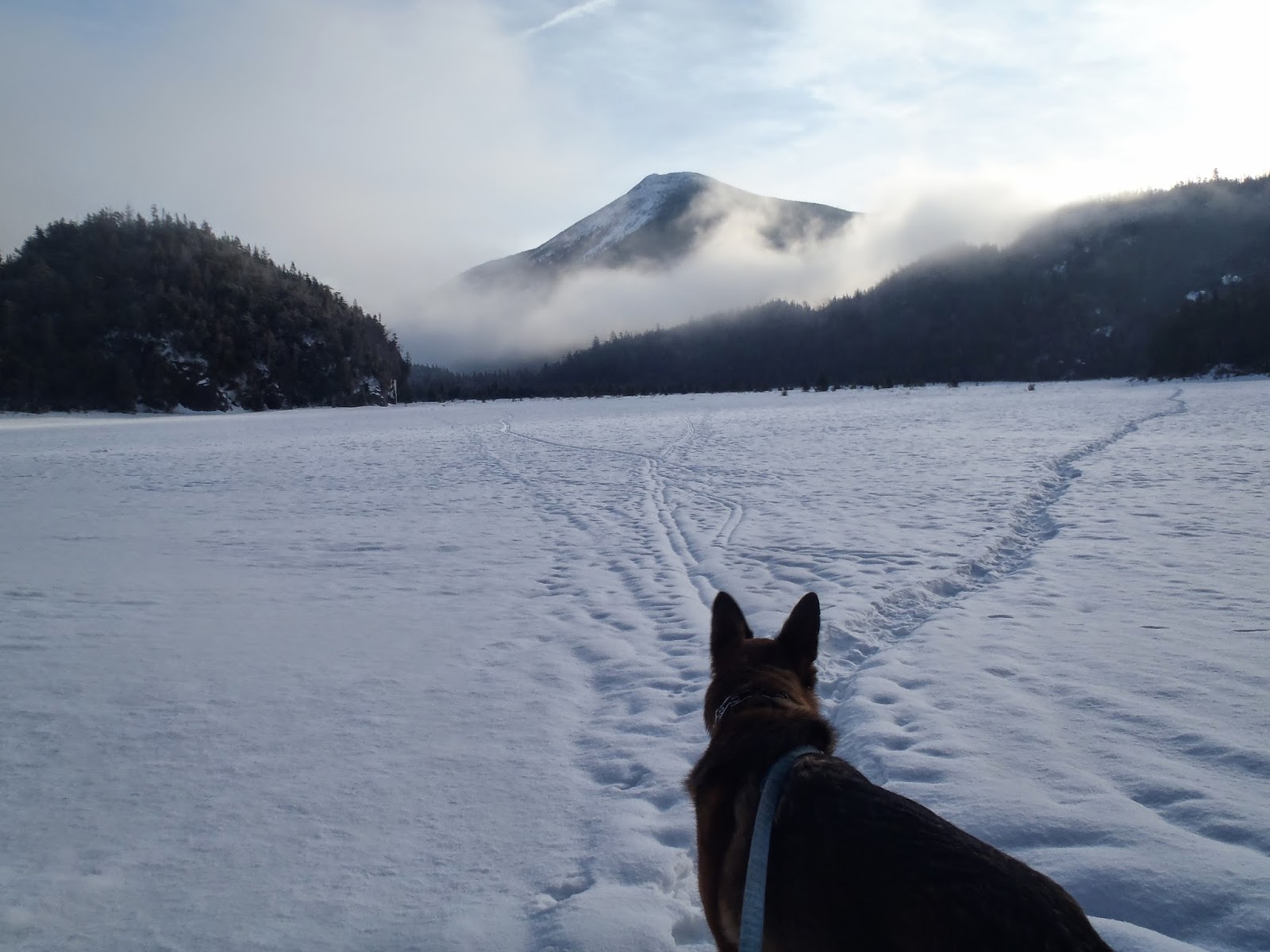
The view from the edge of Flowed Lands did not disappoint. Colden was wearing am ever-shifting skirt of mist. We signed in and I noticed the only recent activity was the Lake Colden caretaker. The trail around Flowed Lands wasn't broken out so I followed the caretakers tracks across. We followed the single snow shoe path across sometimes sinking almost a foot into rotten snow. It made for some uneasy feelings but I figured if the caretaker had felt comfortable crossing the day before, it was probably solid. The Ice deep under the snow turned out to be very solid from the long, cold winter.
 |
| Choose wisely young pup |
 |
| Colden and the dance of the seven veils |
 |
| To the far shore |
 |
| Avalanche pokes her head out |
Now for my favorite trail in the high peaks (Round Pond>Dix is a contender too)! The suspension bridge had about 2 feet of snow on it which was thankfully supportive. It made for an easier cross for Koda and I slightly more nerve-wracking cross for me. All safe across and we enjoyed bright sunshine pouring through the trees as we climbed along the dramatic and winter-stilled waterfalls and gorges of the Opalescent. All of the "trail-breaking" (I guess it's not true breaking if it's only a few inches over a solid track) had caught up with me and I was much more tired by the herd path start than I usually am at that point on the trail. As we had climbed higher, it had gotten less sunny and mistier. At the start of the herd path, we were completely in the mist with about 100ft of visibility.
I saw what I thought was a faint track (uh oh..doesn't look broken at all) and followed it into the woods. I pushed through deep snow looking for any indication of the trail. No such luck... It looked like we may be shut out on this one. I tried to stay calm and not get disappointed. I decided to just keep going up the red trail a little further to make sure I hadn't broken into the woods too early. Sure enough, a much less faint trail was just another 100 or so feet up the trail. It was just about as broken out as what we had been on all day so I was grateful. It'd be a hard-fought summit but we didn't have to quit.
 |
| 100% ADK: late winter edition. |
 |
| "Chris, where are we?" "Koda, I have no idea." |
Off we went, hugging the shore of Uphill Brook. I thought the trail went too far up the brook and turned back thinking I missed the Cliff intersection. Nope, I hadn't gotten there yet. Back up I went. There was some nice open woods and clear trail until the hard right to start the climb. Cliff. Here there was a tree down that semi obscured the trail. We ducked under but not before some floundering off trail.
The climb was pretty straightforward: the usual cliffs had some grippy snow covering the sketchiest parts so while a bit precarious, I never felt dangerous. For the entire day my MSR Evo snowshoes were more than enough. Koda's built in snow shoes did fine too. He often took the lead that day which was a little different. Usually with deep snow he falls in and lets me break trail. Today he made a bee line up the peak and I was decently grateful for his paw prints which gave me purchase on steep slopes several times. Hero dog!!! CoryD got me thinking about his pads so I brought some vaseline just in case and checked them regularly. All good!
Up on the ridge, things were a little less straightforward. Rain and drifts had all but eradicated evidence of the trail in many places. I kept losing the path and plunging waist deep into spruce traps. After wandering in what turned out to be a complete circle (I had double back on my own track!), I finally had the sense to take out my compass and get a bearing for the summit. After that, every time I lost the trail, I'd check the bearing again and use that to choose my path. I had been simply stumbling around the false summit. Quickly now we made our way off it and started climbing the true summit.
It was a challenging climb, which made it all the sweeter to see the sign and disc. Despite it being socked in, we spent a good 20 minutes up top, reflecting on the hike and looking back on our winter hiking season. Koda got his normal kibble and also a special treat: a pigs ear. He got a pigs ear on Redfield in November so it looks like we have a tradition for these two peaks.
 |
| Yesssssssssssssss! |
 |
| The view from Cliff is actually pretty sick. I just sketched it in from memory. |
On this climb, I felt like I not only learned a lot (I still learn SO much every time I hike) but was able to use past experience to aid my way. Having confidence with the compass made it so I never panicked when we were "turned around" on the summit. I'd say one big lesson I took away from this one was not to be so casual with planning. I figured I knew the route pretty well so I didn't run through a few old trip reports or read the guide book for landmarks, mileage etc. Once on the herd path, I wouldn't have had to turn around and make sure I didn't miss the turn to Cliff if I had just spent a little more time preparing.
I wouldn't trade this hike in for an easier version of this hike though. It was a great experience. It felt good to put all of the endurance I had built up all winter and all the experience through the years and hike the hell out of a challenging hike. And still learn. The story goes on though. We made our way back across the summit ridge. Laughing at the floundering track that had caused so much strain not so long ago. I X'ed out all the bad tracks and worked to really lock in the right track for the next hiker (though with how much everything changes each day at this time of the year...who knows). I carefully picked my way down the steep descent. No deliberate but slides but definitely at least 2 accidental.
After summiting at 11, I crunched some numbers again. I could still make pretty good time despite the conditions! I shot to get out of the woods by 4, making for a 9 hour day (in the end, we got out at 3:40 so a little less than 8.5 hours of hiking time). Knowing I had a home-cooked meal waiting for me when I got home was a strong motivator as well. J was going to base her cooking plans around when I sent the out of the woods message on my SPOT. Awesome wife. I was tired and my muscles felt like overstretched rubber bands but it still felt good to move. There were ski tracks on the main trail when we got back there, they looked to be the only others up that way on Saturday.
We flowed like water along the bank of the river, sometimes trotting a little, sometimes pausing at a drop and wonder how far down to the water. Back over the river, through the camp sites and out onto Flowed Lands. What a sacred place. It draws me season after season, year after year. I didn't quite want it to end and hung out on the ice for a while with Koda, once again thinking about all the hikes this winter and through the years. He posed for some pictures.
 |
| Showing off our "mega-leash" system |
 |
| Total goof ball |
 |
| Slightly more majestic here |
 |
| Show's over boys. |
No comments:
Post a Comment