Monday, March 19, 2012

Cliff and Redfield March 17th


Colden and the Macs from Cliff


After a surprisingly successful trip up Esther and Whiteface the previous weekend, I somehow managed to convince Jeanette (even though I promised her we’d do nothing too hard for a while after our whiteface hike) to move forward with our Cliff and Redfield hike.


This is a trip where I felt like lots of planning and research made all the difference. I’d say that for the average high peaks trip thus far, I’d be about 85% prepared. I would always forget something or have a flaw in the plan somewhere. This time I thoroughly read the McMartin and ADK guides, obsessively followed trip reports and made meticulous calculations with many bail-outs and contingencies.


Misty hike in
 
We woke up at 4 AM and were hiking by 7:10 AM. The trail was solid and crusty snow. Pretty quickly we put on our snowshoes to deal with the irregularity of the snow and kept them on for the rest of the trip. We arrived at the blessedly empty Herbert Brook lean-to around 10 and had some pb&j’s as we dropped our overnight gear and I switched to a day pack. Jeanette used my 35L Mountain Hardware pack for this trip so we could go (sort of) ultra light in case we wanted to shoot for uphill brook lean-to. She found this pack to suit her needs pretty well but wanted more pockets!


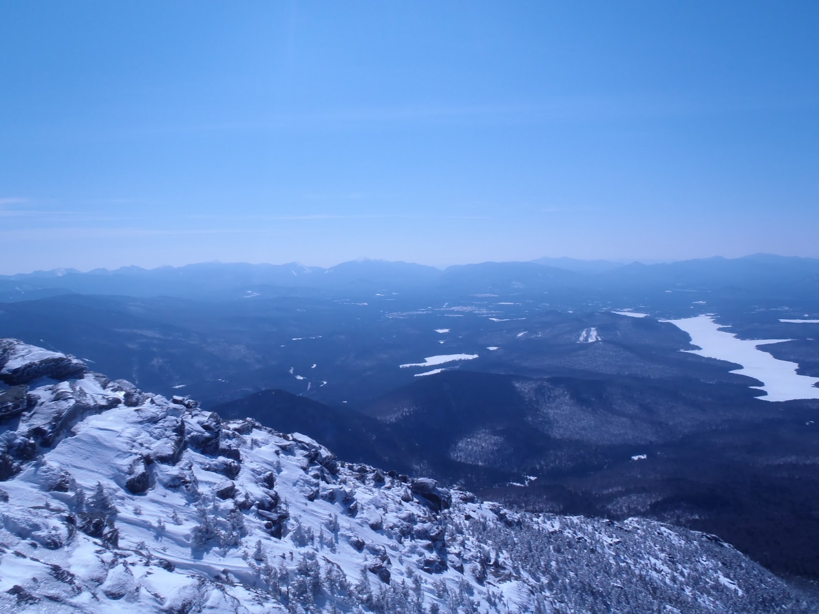
We made great time in to the lean-to and great time up the Opalescent, soaking in one of my favorite trails in the peaks. We stopped at the lean-to/ herd-path intersection for a snack. Though the cairn wasn’t visible (I took note during our Marcy trip), the herd path was a highly visible “sidewalk”. We decided to get Cliff out of the way first, as Jeanette had some anxiety about the cliffs.


some inversion off to the south. heading up Cliff.
 
The first section of trail was very pretty, though moisture was coming off all the pines and getting us kind of wet. This ended pretty quickly as the trail opened up. This open area in the col is because of blow down from Hurricane Floyd? It was immediately pretty clear how Cliff got its name. The steep sections were tricky, especially with the increasingly rotten snow. Jeanette was pretty anxious and upset and I did my best to calm her down and encourage her. Just as she’d had enough, we reached the top of the ridge. I loved the views from the false summit and summit and was grateful to be there with the snow lifting us out of the trees a bit for better viewing.


cliff summit. Happy and alive


We didn’t stay up top too long, with a long day ahead. The decent was surprisingly fast, the tricky sections we found to be far easier descending. 45 minutes back to the intersection and then up the Redfield herd path. This trail was beautiful and much easier right from the start with firmer trail conditions. Like Esther the week before, it was readily apparent that I’d be returning to Redfield. Though lovely, the final ascent seemed to drag on and our endurance and will were tested (already 10 plus miles into our day!).


Left to right: Marcy, Redfield and Skylight. Redfield is the little wooded bump.


The summit was simply stunning. We had it to ourselves and it felt so still and so epic. I felt like I was in a holy place. We ate and rested, sitting down for the first time since Herbert Brook lean to. After our snack I sort of hunched over, with my face in my arms, completely drained. I looked over and Jeanette was in the same position. We both let our weariness and stress pour out of us and were greatly relieved and cleansed. After some pictures and final revelry in the increasingly golden light, we began our descent.


Gray, Marcy and Skylight from Redfield


Blessedly easy on our legs, we felt like we rolled down and out, taking some pictures and pumping water along the way. Leaving the summit at about 4:15, we reached our lean-to around 6:30. We cooked dinner, got into our cozy clothes and laid down for the sunset.


The Macs from Uphill Brook


It was beautiful, as were the stars soon after. Jeanette fell right asleep and I tossed for a bit, as I had forgotten how to sleep on wood in a mummy bag. After curling down a bit so I could see the stars, my body remembered and I got more comfortable. We both woke up around 3 Am pretty damn cold. If we had it to do over, we both would have brought a bit warmer clothes. We fell back asleep until sunrise. We chatted and cuddled until around 7.


Sunset over Flowed Lands


After cooking breakfast, we got our ish together and began the hike out. Pretty immediately we were tired (mentally and physically) and the 5.7 out was pretty tough on both of us (I think more mentally, we were both “over it”). Like all hikes, it did eventually end. The car was welcome site. We both made utterances of pure ecstasy as the boots were removed.

The next morning


Monday, March 12, 2012

Whiteface and Esther 3/11/12

          With a mild weekend and navigable snowpack predicted, the chance to climb some new high peaks arose. We arrived at the Atmospheric Science center at 8 and after slowly getting our stuff together and a bit of wandering around looking for the trail start, were on our way up Marble at 8:30. The initial ascent was a straight shot following the old lift line foundations I think(?) and a bit of a slog.

   There were nice views to be had at the intersection with the main trail. The camp site here is also compelling. The trail up lookout was quite pretty and we started to get some nice views through the trees. This part of the trail flew and we were soon at the intersection with Esther. There is a large cairn and a sign. Can't miss it.

   This was a lovely herd path, which was well packed out. The whole hike had well packed out trail, great for snowshoeing. enjoying the 4000 ft views in all directions we reached the summit in no time. The whole phase one of this hike flew by. Beautiful woods, gradual ascent and high spirits.  Back we went. We started running into people on our return and our thrall dissolved a little bit as we entered a different phase of our journey.


Esther Summit looking back towards Whiteface

     After about 15-20 minutes we reached the top of the lift for lookout mountain. Our good friends Erin Baxter and Christopher "Weekend" Moeller met us for a pow wow. They were spending a romantic weekend up at the face with their cat. It was great to spend some time, deliver Weekend his meteorite and sit down on a bench for a moment. Baxter had hard boiled eggs for us which fueled our final ascent.


Shredstars and sumitstars!

    In no time we began ascending the final push up Whiteface. Views opened up of the ski trails and we got to see people skiing and the lifts operating in miniature. Pretty neat. The trail opened up to the side of the highway, where there was a fairly steep section followed by a step up some ice. Jeanette came into this hike with some (and rightly so) fear of Whiteface Mountain. It's a very challenging ski mountain and the conditions are often even more challenging. With these feelings combined with some nerves about winter hiking in general (also, rightfully so), Jeanette got a little freaked out.


The final push along the arete.

Looking back
 
    She got up the steep part in snowshoes with no trouble and we sat down on the road for a switch out to crampons for the icy step up. This was also quickly reckoned with and we began our final ascent. Though still battling with (and overcoming) fear and anxiety, Jeanette pushed forward and was able to calm down, as the last stretch looked much more perilous than it was. The last section of trail along the arete is breath-taking as the ADK guidebook promises. Beautiful views out to the high peaks down south and vertigo-inducing views down into the slides. It was cool to do some recon on the slides for future trips on Whiteface. The second half of the pitch looks very manageable.


Possible slide access routes (?)  following natural lines

    We shared the summit with the usual gaggle of French Canadians and enjoyed our PB and J's. After some exploring and pictures we were ready to go. It was difficult to see on the map but it looked to me like you could walk a short distance down from the summit to the parking area. I started leading us down the west side of the summit where the observation machines are against Jeanette's best instincts. We realized after heading down a few hundred feet that this was the trail down to the lake. We went back up to the summit and trotted back down the arete to the road.

lake Placid and the other 44 from Whiteface summit


     The first stretch of road was intensely wind-blown. After getting in the protective shadow of the mountain, it dissipated and we needed to put our snowshoes back on. At this point we ate our summit chocolate and were recharged for the next bit of walking. We made good time and chatted more wildly as the mountain trance set in. Once time started to slow and our feet got to the point of being beyond sore, the snow thinned out and we were able to start bare-booting again. We sat at one of the many picnic tables and gave our legs a break.
Bare booting down the highway

    The final push wasn't terrible and as we approached the booth our spirits raised. Along the last half mile of trail, we saw numerous "dog" tracks and wondered if they might be coyote. On the last section of road walk, my feet became kind of deadened and sore. I could barely lift them! Back in the car at around 5:30. We hiked for around 8 hours with about a 1 hour of down time. Though sore, we both felt strong and appreciated the time we had been recently in the gym. 

   I took my time getting my boots off and having a snack before heading out and reflected on the hike. The weather was stunning, 30's in the morning and probably close to 50 at the highest, with a long afternoon and evening thanks to the spring ahead. I felt blessed. For my girlfriend, my buddies, this beautiful world and the opportunity to explore it.