Monday, September 15, 2014

Macomb's 1947 Slide> the Dix Range without Grace

Brian and I met at the Vespers ceremony before the 46er banquet when Jeanette and I received our certificates. Actually it was about 10-15 minutes before Vespers.Let it not be said that the Sobik family isn't punctual. I was on the fence as to whether I wanted to go. My mother expressed interest so we went while my dad and Jeanette rested in the hotel room. He had just returned from a hike with some interesting weather and was updating his spreadsheet. The room was  empty since we were still early so we ended up chatting with him. He knew me immediately from my postings on the high peaks forum and I was very familiar with his name and reputation for being an amazing dude. He said some truly kind things about my writing that made me feel really good. I think my mom felt super proud of me too. Going into Vespers on quite a high, I was deeply moved by the ceremony. The whole day and weekend (spent with Jeanette in my parents in the high peaks doing the things we love) had me buzzing. There may have been some wine involved as well.

That fall he contact me to go on a hike. The plans fell apart due to other commitments on both ends but I vowed to make sure we did get out there one day. After seeing my posts inquiring about the old way 46ers used to climb Macomb (up a different slide to the south of the one climbed today) he invited me once again and I jumped at the chance. He invited his buddy Suvrat along and I'm glad he did because the 3 of us had a great time on this hike.

We left the already full trail head a little after six. I met a couple about my age heading in to climb Haystack into Blake. I thought that sounded like a really cool route but a big day for sure. It was already much darker in the morning then its been all summer as the seasons are changing. We made some standard chit chat that made the initial 2.3 miles go by in a wink. At the start of the Macomb herd path, we got out all the various navigation aids and hatched a plan. We'd follow the modern herd path for 10-15 and as it peels away to a ridge high above Slide Brook, we'd drop into the drainage and start looking for the first major tributary entering from the south.

Dropping down the bank, I unearthed the first of several archaeological finds: a blaze orange match safe. After evaluating the banks, we decided to rock hop right up the creek. The going was somewhere in between hard and easy. It seemed like we had gone a bit too far though. Brian checked his GPS and confirmed. Rather than backtrack down the brook, we headed pretty much due south up and out of the drainage and immediately heard the correct one burbling away through some pines.
Typical Field Conditions
With some nice open spaces
We navigated around downed trees


 We followed this tributary until eventually we could see a break in the trees to our right. Figuring it was the slide base, we popped out to find deeply eroded creek bank. We got up on it to take a look around and got a good look at the slide track and rocky crag of the Macomb sub-summit, our destination. Views opened up over our shoulder to the Pinnacle Ridge and Allen. I found an old Reliance brand water bottle Brian said he'd had one of in the early 80's. A perfect artifact to date this old route. The eroded bank faded back into woods so we made our way back down to the stream and followed it until we reached another, very similar bank. More creek walking eventually led us to some preliminary slabs and some early views to Elk Lake.

We reached an eroded stream bank where we could see our goal
Brian for scale

Brian and Suvrat take in views to the southwest.

Rubble transitioned to a mix of slab and creek

The first pitches were blocky and gradual, a nice warm up for the coming climbing. Eventually the view opened up even wider and we found ourselves at the base of a size-able slab with a lot of water pouring down it. We could also see the rubble slide angling down from the sub-summit crag to our left. We worked around the base of the slab and made our way up onto the rubble. While the pitch is a little less steep than the modern Macomb approach, it's a lot messier and we had to work really hard not to smash boulders down on each other. Eventually Brian found a line on the left which had some exposed slab and was easier walking.
A sheet of water trickling down
Elk Lake comes into view, feeling much closer than it does on the standard slide route


I think this was Suvrat's favorite place on the hike

A splash of early fall color

Looking down the transition from rubble to rock

We worked our way up gradually, getting closer and closer to the cloud ceiling which at this point was clinging to the crag. There was bright red on the rocks as we got higher. We debated whether it was iron or lichen. Or the old red blazes marking the route. Or the ink pack from a bag of bank-robbed money.  The rubble gave way to rock again and an imposing rock face greeted us out from the swirling mist.

Iron oxide(?) on the upper reaches of the slide. 
Big smiles all day from Brian

When we got our first glimpse of the crag I joked that I was going to "Mudrat" right up it as it looked way too steep for my comfort. I thought we'd have to work around it As we got closer it looked less tricky than it first appeared. The quality of rock was good and there was a number of hand and footholds .Brian and I made our way up the middle of the face while Suvrat chose to stick to the steeper, but more protected tree line. We all eventually met up top in a protected area under a significant overhang. Suvrat realized he was one pole short! We found a nice line down to the base of the slab (turns out there was a number of ways we could have worked up this section), climbed back up his line and found the pole half way.

 From here we climbed steeply, sometimes on rock, sometimes in the trees until we broke out on the ridge line. A couple of spots felt very challenging for me, not so much because of the difficulty but more-so to do with the exposure. There was one spot where I had to move out of the protection of the trees and onto some rock with lots of exposure seemingly plummeting into a foggy abyss. A maybe slightly over-dramatic description. Call it poetic license. I  did my best to stay focused on my points of contact, what my next move was and to keep my heart rate down (Mudrat often mentions the heart rate thing in his trip reports. Thanks!). We all successfully made it up onto the ridge! At the ridge we noticed a bit of path leading right to get out onto the open rock of the sub-summit. We stepped out onto what I'm sure is an impressive view of the Macomb ridge and the rest of the range. I was too elated from the climb up to have any irritation about the lack of views. The summits were obscured in clouds and would remain so for the rest of the day.
The initial pitch


Foggy climbing
The wall


Trekking pole retrieval project


The sweet protection of the overhang
Staring into the abyss

The first stretch of ridge heading north was very thick with blow down. We zig-zigged our way north, with an occasional compass check to verify we were on track. The going got easier bit by bit until we started picking up patches of the old herd path. So cool to see! From that point on, it was the hunt for the lost herd path with the group at times fanned out along the ridge looking for it. Great fun and adventure. The woods were lovely with patches of fern and dangling moss.

Fragrant and lush
Ferns, moss, evergreen and lichen
Not sure what these mossy/ lichen-y dudes are called but I really dig them


Fragments of herd path
We eventually broke out onto the herd path about 75 ft from the summit. It felt odd to be able to walk unimpeded after carefully choosing each step for the past several hours. We took a few pictures, then a group of five Clarkson Freshman gave us one of my favorite summit experiences of all time. They were from their college's outing group. After the weekend, everyone in the club gets together and has a slideshow of their weekend adventure. Whoever has the best slide show gets their gas paid for! In order to amp up their slide show, these guys managed to hike up a Sesame Street-themed birthday cake in one piece to the top of Macomb. Everyone on the summit, including a group that arrived after them grabbed forks and dug in.

My first time eating sheet cake on a high peak

I feel like it fared pretty well considering the adventure it just had
Summit cake!

Still buzzing from cake high, we deliberated and decided to continue up the range. Now on trail, we were able to make good time to Carson. Afterwards I thought about an interesting phenomenon I've noticed during  hikes when the visibility is low. All day, I felt like I was constantly in little rooms. Sometimes the room would have a creek running through it, sometimes you'd be clinging to the side of a mountain in the room. You'd turn a corner and there'd be a bunch of people in the next room. Always enclosed though. Almost like a first person shooter type video game. At the intersection with the Lillian Brook col, we met around 7-8 ladies who Brian gave expert advice and directions to. I think they found him quite charming. It was a fun climb up the Carson rocks. After climbing the slide I think we all felt good about our climbing chops and chose to go directly up some rock we really didn't have to.Cavalier is the word Brian used.
The fun scramble of Carson
Brian and Suvrat enjoying the high
 It had gone from merely misty to rainy on Macomb and this was to be the conditions for the rest of the day. On Carson there was some debate about Grace. As I had climbed it a few weeks before, I lobbied to skip it and continue own. Despite needing it for his September round, Brian agreed. Once again, quite the gentleman. We doubled back and continued along the bumpy ridge to the base of Hough. At the intersection with the main branch of the Lillian Brook herd path, there was a small steak knife jammed into a tree stump. Brian didn't want to leave it up there so devised a plan to get it down the mountain without ripping his bag. He disassembled his treking pole and put the knife in the hollow center section! Watch out for Summithat on the trails now folks. He's carrying a concealed weapon.  Everyone still had energy and good spirits so we climbed Hough.
The wind-tortured Hough tree

ear to ear smile all day
We couldn't get any wetter so decided to continue on to Dix. This was my first time going from Hough to Dix and I really liked the trail. I think it'll be well worth another visit in better weather to get the views from the numerous overlooks. There were several fun scrambles and the feeling of being in a small room with an ever-changing floor wouldn't leave me. It allowed a closer focus on the immediate surroundings. The moss, lichen, weather-wracked trees and rocky ledges. We went up and over the Beckhorn and stood on the summit of Dix. The wind was whipping across so after a minute with the Colvin bolt, we headed back to the Beckhorn trail. It was quite an interesting jungle gym style descent with horizontal rain into the abyss.

About half way down either the hike had caught up with me or the cake power had run out. I was pretty tired. The trail seemed to drag on a bit but we eventually found level ground and the intersection. From here on out we took turns leading and made great time. I think everyone was ready to be out of the rain and in some dry clothes.Any time anyone up front found bad trail (up hill, muddy or rocky) there were scolded and sent to the back of the line.Things got much sillier in general in the late stages of the hike and eventually some Big Lebowski quotes got thrown around. The true mark of a successful hike. We made it out of the woods by around 6:10, making for a 12 hour day in with about as varied as an experience as you can have: on trail hiking, off trail hiking, slide-climbing, route finding, trail re-discovering and 4 high peaks summits.

Despite no visibility, constant drizzle and high winds, I've rarely had more fun on a hike. Company makes all the difference in the world. 

Sunday, September 7, 2014

Dial and Nippletop double bushwhack 5/18/14 (Gravestone Brook and Noonmark Shoulder)

There are 3 specific hikes you have to do in order for your dog to become a 46er to avoid the Ausable Clubs no dogs allowed policy:
1) Sawteeth from the Garden
2) Colvin and Blake along the Pinnacle Ridge
3) Dial and Nippletop from Gravestone Brook

This would be the second of 3 with Sawteeth still to go. I guess technically you could access Dial and Nippletop from any number of points to the south but the Gravestone Brook route is kind of the default at this point. After several discussions and a few back and forth emails Bill Brizzell (BillB on the forum) and I decided on a day and a route: we'd go up Gravestone Brook and finish with a bushwhack to Noonmark Mountain.

I picked Bill up around 4 (Ok, I was pretty early, I'm a dork) and we headed up the Northway listening to the Newly remastered 8/27/72 Grateful Deal performance to benefit Kesey's failing dairy farm. The sun seemed to rise early over misty valleys and mountains. It was shaping up to be a beautiful day. We hit the Round Pond trail-head pretty much at 6 which was surprisingly full. I guess it always seems that way since it's a small lot on a trail to a popular mountain.

The trees were budding and hobblebush lined Rte. 73 and the lower elevations of the trail. I immediately saw several patches of purple and painted trillium which always makes me smile. I might have seen a few trout lilies but I think they weren't quite out yet. Koda was great on the drive up and quickly made up for that error by picking up the biggest stick he could find and gave us a few whacks. Round Pond looked lovely with the moon hanging over the far shore.


We made good time in the crisp morning air and before long, hit the intersection with the old Dix trail/ Noonmark trail. We kept chugging along and started catching glimpses of the Boquet River. As we peeled away from it we started watching for the crossing of Gravestone Brook. We had 2 false alarms before hitting the true brook. Like Telemark Mikes Report, it was the one with a set of stone steps on the other side. We started up the western shore which was sort of thick. After a while we made our way down and checked out the eastern shore which was more open and actually had a game trail/ faint herd path to follow for quite a while.

As we got higher, the stream braided in places and smaller tributaries drained in. Always we were surrounded with the sounds of moving water. We began making our way more along the shoulder of Dial rather than the col between Dial and Bear Den which is where most people have gone in the past. The woods were open and after realizing the trajectory we were on figured, why not? It's where we wanted to go anyway. As we got into some steeper territory there were some rock walls we had to skirt around. just as it was starting to get a little tough, Bill saw a trail blaze! I was pretty excited and did some cheering. Bill, whose done lots more of this than I have took it a bit more in stride haha. He knew we'd hit the trail eventually. I always have it in the back of my mind that I never will. I guess a bit more experience and I'll believe too.

It was a pleasure to be back on trail with the first major question mark of the day turned into a period. The trail was dry, firm under foot and ice free till about 3900 ft. Much better than expected. Within 15 minutes we reached the summit of Dial. First off, I always forget how low Dial is. It just made the cut! Secondly, the views from these two peaks are just phenomenal. It was a perfect day for it too. Since we started early and were hiking on a Sunday, we had the summit to ourselves. We enjoyed the views for what I would consider an average amount of time before heading off to Nippletop.


The going from Dial to Nippletop was nice and easy. As we got a bit higher there was more ice spine left. At one flat spot on the summit ridge snow was piled 3 feet deep. We guess it probably piles up over 10 feet there in the winter and you'd have no idea as you walked over what you thought was flat terrain. With a bit more climbing we passed the Elk Pass intersection and reached the stunning summit of Nippletop. While views are similar to Dial, you're higher and have a slightly different perspective, seeing a bit more of the rock on the lower range and views ranging down the Pinnacle Ridge. Here we sat for quite some time feeling lucky to have it to ourselves. I felt very much alone in the woods. We ate and I fed a very muddy Koda. I had brought bacon and hard-boiled eggs for breakfast. Since my yogurt held me in the morning, I got to enjoy the nice burst of protein much later in the day.


After sopping it all up for quite some time (grateful to be able to do this after running off the summits all winter), we started making our way down. The hike had finally caught up with me a bit and I didn't have as much steam as before. By the time we hit Dial again, my knees and feet where feeling it. Here we saw our first people, a group of 3 guys on the summit. We chatted for a bit before making our way down. We passed several more pairs of people on the descent. While Noonmark looked very far away from Nippletop, we kept getting closer and closer. After a steep descent of Bear Den, we began climbing the burn area on Noonmark. Though we both took several pictures along the way, the overlook on the burn was too good to resist and we got a bunch more shots. We took our bearings and made our way into the woods.


The going was slow through thick thick pines. Thankfully they were bigger than the Alpine krummholz so we were able to push through. Both Bill and I donated some blood while Koda picked his way through. This was much harder work for him than anything he's used to. He general runs along trails and through open woods. I knew he was going to sleep well. Some faint deer trails and lots of deer pellets gave hints of the animal life there on the ridge. We encountered a little garter snake all curled up on a branch in a small clearing. We kept catching glimpses of the rocky crag of Noonmark through the trees when they occasionally thinned. At this point I felt pretty drained and was happy when Bill had the bright idea to stop for a snack. It was just what the doctor ordered.

As we began to encounter more significant rocky areas, we had to pick our way through some chutes and over some steps. A few times Koda led the way while we were trying to make a decision. He never steered us wrong. The vegetation didn't subside until we were right up against the crag. I was hoping to hit a wall that might have established climbing routes and therefore a herd path back to the main trail. No such luck. We side-sloped along some low (but not low enough to climb) walls looking for a way up. The terrain got steeper until we were walking along some wooded ledges.

We eventually reached a bit of a dead end where the only way was up some big stepped ledges. Koda tried his way up and slid back down a few times, getting pretty anxious in the process. Bill decided to go up top to check things out for us. If we got Koda up there and it was a dead end, getting him down would be a pretty big problem. Once up, things looked good for a clear line to the summit. I gave Koda a boost and Bill grabbed his collar/scruff and helped haul him up. It was a relief to have all of us safely up. In the end, this wasn't any trickier than other stuff we've done together but the isolation of the bushwhack and the uncertainty of the terrain had me worried.


Quickly we ascended the remaining slopes before coming out on the low ledges facing Dix I'd spent a long time on the first time we climbed this peak. Awesome! Second whack was a success and now to soak up some summit glory. There were a few groups milling around and taking in one of the best views in the high peaks. We relaxed, snacked some more and took a ton of pictures. A nice couple asked me to take pictures of them and they, in turn, took some pictures of us. I'm always glad to get pictures of Koda and I since we often hike entire days without seeing other people. I particularly liked the shot they got of the three of us. There is a permanent puddle on top of Noonmark and Koda was completely in his element, splashing around.


We hung out for a good long time before picking our way down the steep trail back towards Round Pond. I kept missing the soft snow and gliding snowshoes steps of winter hiking. My knees felt jarred and my feet hurt. In the winter I was able to travel many more miles before feeling that way. The creeks flowing in to Round Pond were pretty and one looked sort of like a water slide. I took several more pictures of trillium as we reached the end of the hike.

Bill's GPS said about 16 miles when we reached the trail-head. It was a great pleasure taking off my muddy boots and letting my feet breathe again. This was a very memorable hike with perfect weather conditions. It was Koda's 39th and 40th high peak. He celebrated by sleeping all the way home.

Thursday, September 4, 2014

Camping and Climbing with Grace 8/30-31/14

It turned out that two of our friends who we love to camp and hike with were free Labor Day weekend and wanted to get out. As excited as we were I knew it would be tricky to plan a trip during a busy holiday weekend. In the spring I took a friend from growing up on a tour of the Boquet River valley waterfalls, visiting the falls along the fisherman's path where the North Fork of the river takes a 90 degree turn. The falls were absolutely stunning and the camp site was the stuff of dreams. I vowed to revisit for an over night and it seems like the stars aligned for this trip.

With it being LDW, we had a bunch of contingency plans: park further south on 73 if parking was full, maybe even go in the south fork trail and camp there if it seemed like the herd path camp sites would be full. We got to the trail head around 7 on Saturday and there were plenty of spots. We got our gear situated and started across the road and into the woods. Caroline (our friend, along with her boyfriend and our long term friend from college Josh) were immediately impressed with how soft under foot and pristine the trail was. I feel the same way! I had some concerns about crossing the river with our full packs but everyone made it over ok, other then Jeanette dipping a toe in a little bit.

Now on the far bank, we followed the trail through beautiful forest and enjoyed conversation fueled by the remaining caffeine in our system. Koda frolicked along the river bank splashing and barking with joy. In about 30 minutes we reached the turn off for the fisherman's path. Since most everyone uses this trail to climb Grace, there are lots of birch logs covering this path, "brushing it out". From here the trail is more narrow, with more branches reaching in, indicating how seldom it's used. I was optimistic we'd have the site to ourselves but was perfectly ok with pushing on to Lilly pad pond as the day was young. The sounds of the river rushing over the falls greeted us from far below and to the left. As we approached the small knob of land at the top of the falls I could see that the site was vacant! Our home for the night.

We gladly unshouldered our packs and set up our tents. While the site doesn't have a ton of level ground both couples found decent enough spots. After everything was set up, bear cans were stashed and day packs organized, I brought the group down to the falls. In bright morning sun, nothing could appear more inviting than the swimming hole not 100 ft from our tents. When I was there last, the day was overcast and I couldn't tell how deep the swimming hole was. It was close to 15 ft in the center! the sides fell away steeply making it an ideal swimming area. Koda thought so and was in it immediately. The plan was to swim when we got back. It was time to hike!!!


We moved quickly but relaxingly through the woods, enjoying the peace and serenity that a quiet path can give your heart. After a mile we ran into a guy making his way out with some sort of metal tube in his hand several feet long. No idea. Fly rod case? He was the only person we saw over the entire trip. It seemed longer than I remembered getting from the fisherman's path to the last designated site with a decent amount of climbing. I was glad we only carried in the overnight stuff a mile or so. We enjoyed crossing the beaver dam which was covered in orange flowers.


The camp site at the falls/ swimming hole confluence was also unoccupied. Where was everyone? there were around 6 cars at the lot when we got there. The upper reaches of the South Branch felt just as wild and isolated as our first time up that way the summer before.It was nice to have a general feel for the trail, making the multiple crossings less stressful. We continued climbing and eventually made our final cross, heading southeast after hiking southwest for most of the day. Larger slabs in the creek indicated we were approaching the slide base. About 15 minutes before this Jeanette asked "Is this the one with the slide?" Last year, in somewhat dramatic fashion, she decided not to do it and took the herd path up. Koda and I climbed the slide and all agreed we didn't handle the situation as well as we could (fingers pointed in this general direction). Judging by the type of questions she was asking, I got the impression she wanted to climb it this time. I was excited and surprised. I actually hadn't planned on going up it but was all about supporting her overcoming fears.


A few more questions, some group-wide reassurance and up we went, navigating the slippery lichen at the base of the slide. Man it's slick! I kept telling everyone that it dries out and the rock gets much more grippy as we get higher up. Koda often went up the slime, much to my irritation. He is actually very open to direction when we are navigating stuff like this so I tried to keep an eye on him and point out the dry ways up. The slide is seemingly broken up into little sections. You make your way up one, finding a resting spot and start the next. The slide did continue to get drier but the stone didn't get all that much grippier until the final third or so.While Jeanette was scared and needed some encouragement she was determined and was able to make really good and confident moves. Josh and Caroline seemed to be enjoying themselves as well. Koda plodded up, continually looking back at us as if to wonder why we were going so slow. The views are simply incredible from the slide.


I knew the final ascent would be the make or break for the crew. I also knew it was the last good bail out (the herd path leaves the side of the slide at this point and heads to the col between Grace and Carson. Well..... while Jeanette said no way and may have uttered a few expletives, she immediately started heading up. Here we go! The rock gets much more coarse here (changes from ??? to Anorthosite?) and there are numerous cracks to work up. While she was at times very scared (I felt her pulse...intense) Jeanette kept at it, asking what was the next safe move and if she should continue on her line. Koda and I scouted ahead while Caroline and Josh (naturals on their first slide climb) found there own way more nonchalantly than I did.


 While each pitch got successively steeper, the rock was grippy under foot and there were always cracks to work, trees to stabilize. There are more protected or more exposed routes, depending on your comfort. It was way more fun for me than the last time. I felt safer being with people and didn't have that foul feeling in my gut I got from separating with J the last time. Koda had a ball too and didn't slip at all on the upper portions.


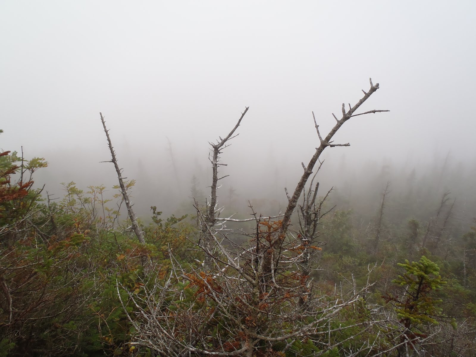
The sub-summit crag (where the slide tops out) was now very clear and pretty close. Here the slide narrows into patchy scrambles with faint herd paths through the trees in between. I think I made a few wrong turns the first time and had a much easier go on this part this time. It's also nice to know approximately what's ahead of you to keep the heart rate down. There were a couple more steep spots J needed some coaching to get through but she often took a less protected or more vertical route than the ones I was suggesting. She's a closet bada#$. We were now just below the summit, in a deep fissure underneath the impressive crag. Josh took a slightly different line than us and ended up stuck  unable to get any higher. We were all nervous for a minute but he safely down climbed and followed us the rest of the way. We all topped out and celebrated. 


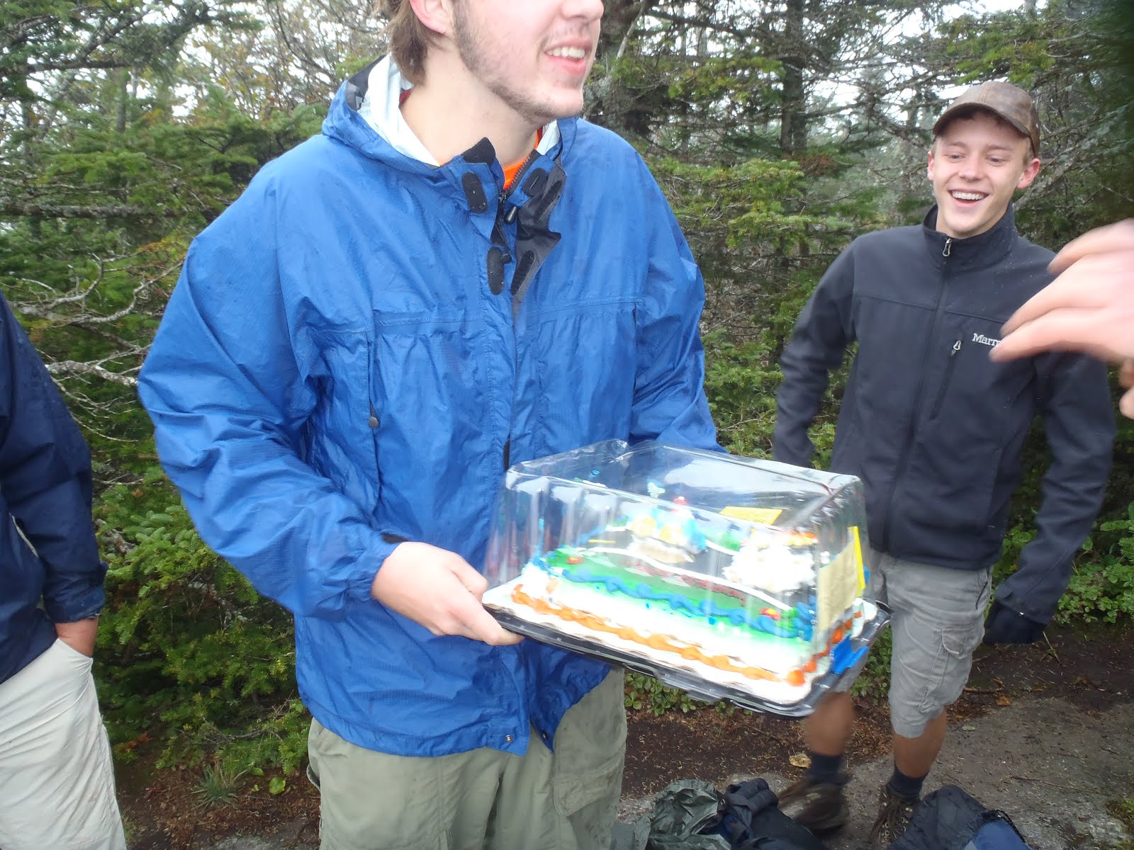
What an adventure! What a climb! I know folks out there do way bigger and badder stuff than this but the high we got at the top of that slide couldn't be beat. The sub summit view is slightly better than the main summit in my opinion. Also, if the main summit is crowded, you can  find some peace here. We decided this would be our chill spot and we'd enjoy our snacks there just in case the true summit was crowded. Koda got his favorite summit treat, a pigs ear (I love it too because it gives me 15 minutes of quiet time) and the human climbers got chocolate chip cookies from the amazing bakery Our daily Bread in Chatham, New York. After a long rest, lots of pictures and dramatic retellings of the climb, we headed over to the true summit which was also empty...not even a sign. We took a bunch more pictures, soaked in the views into the Southern Dix Mtn Wilderness and started down to the col.


Just as we dipped down onto the herd path that takes you into the South Boquet Valley we heard voices coming down the trail to Carson. So the rapture hadn't taken place! We quickly scooted out of there, not wanting to shatter our feeling of desolation. I think we went temporarily feral. The decent went quickly with soft trail under foot. We encountered little to no blow down all day. The trails were in great shape. The hike back to camp was a delightful blur, with lots of chuckling falls and sun dappled trees. We got back to camp and quickly got into some truly refreshing and delicious water. We swam for about 45 minutes and explored all the way down to the top of the big falls. Very impressive and fun. Josh noticed there was a ton of driftwood down at the base. we gathered several arm fulls, got dressed and ready for dinner. Josh and Caroline brought cheese, crackers and salami (and Jameson's) so we had a makeshift happy hour. We made a mix of andouille sausage, quinoa and peas. I actually hiked in a small can of peas which was a fun throwback to old school camping trips.


The driftwood fire started more easily than any fire I've ever started in the woods. It crackled, we chatted and got more and more sleepy as the night closed in. Koda was restless at first on his 20 ft leader but as it got dark he passed out hard and it was quite the challenge getting him into the tent for the night. After extinguishing the fire with several pots of water it was time for bed. Koda slept between us at our feet and all 3 slept hard for 10 hours.

We woke up close to 8AM. The luxury! We couldn't believe how late Koda let us sleep. He's usually up at day break. He's getting more and more mellow every day. Thank the lord. It was truly nice to pack up and eat breakfast at a leisurely pace. We often feel like we are rushing out of the woods. Today, it was in the plans to just relax. It was overcast and it had drizzled several times over the course of the night. We threw pack covers on and had rain gear either on or at the ready. On the way in, we decided to save the waterfall I believe is called the high dike falls for on the way out. After about 10 or 15 minutes we could hear it through the trees on our right and could catch glimpses of large, open rock slabs.

We dropped packs on the trail and made our way down an obvious path to the top of the falls. When I had visited it in spring the volume of water coming over and through the falls was truly impressive. On this day there was significantly less and a large portion that had water coming over it was now dry, allowing closer investigation. We hopped over the top of the falls, feeling a little Indiana Jonesy (apropos as as we all are or were atone time archaeologists) and climbed down to the base. The open area had an almost man made feel and was quite striking, like the plaza of a temple complex.

Once again, the difference in flow between August and early June revealed more secrets of the river. There was a VERY deep swimming hole at the base of the falls I couldn't see before. We peered into inky blackness, seemingly without end. Koda, after testing his footing and exit possibilities, plunged in. We were content to view and relax. I will return and swim there one day. The rest of the hike went well and pleasantly with an easy return crossing, dreams of Stewart's coffee dancing in our heads. The trail head was pretty quiet, with about 4 cars (besides ours) when we got there around 10. We caravan-ed to the Schroon Lake Stewart's for coffee, breakfast and good byes.

Words cannot express how much I enjoyed this trip. It had all the elements I love about a high peaks trip and sharing it with my wife, friends and dog truly enhanced the experience.